This fabulous family walk is in the heart of The Somerset Levels.
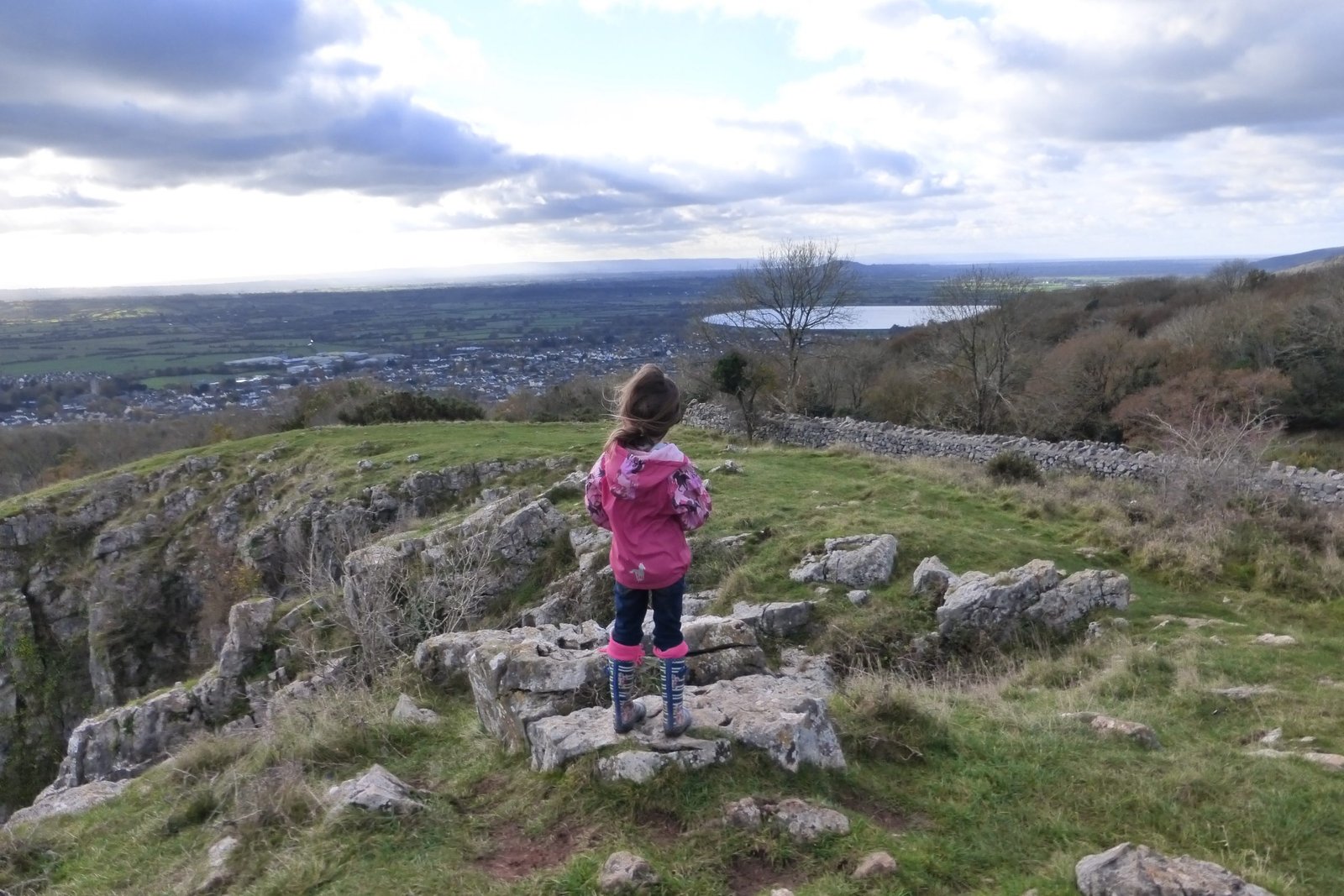
Burrow Mump, (the mini Glastonbury Tor) is one of Somerset’s hidden gems. This prominent hill with ruins of a church at its summit, is only a short climb but the 360° views are far-reaching across the Somerset Levels.
Walk Information:
Distance: 5 miles
OS Map: Landranger 182; Explorer 140
Elevation: 24m
Dog Friendly: Yes but need to be kept on a lead when around livestock
Start/Finish Grid Ref: ST360305
Accessibility: Not suitable for wheelchairs or pushchairs
Parking: NT Burrow Mump car park off the A361 (free) limited spaces. TA7 0RB
What3Words: toasted.vehicle.snowballsWalk Highlights: Historical monument, river, views and a pub lunch!
Things to note:
The first part of the walk is a short but steep incline to the summit of Burrow Mump. This section can be avoided by walking around the base, if you prefer. The rest of the route is flat across the Somerset Levels.
There were sheep grazing Burrow Mump when we walked this trail, so dogs should be kept on a lead. The route also takes you through farmland with cows grazing, so dogs should be on a lead for these sections. 
About Burrow Mump
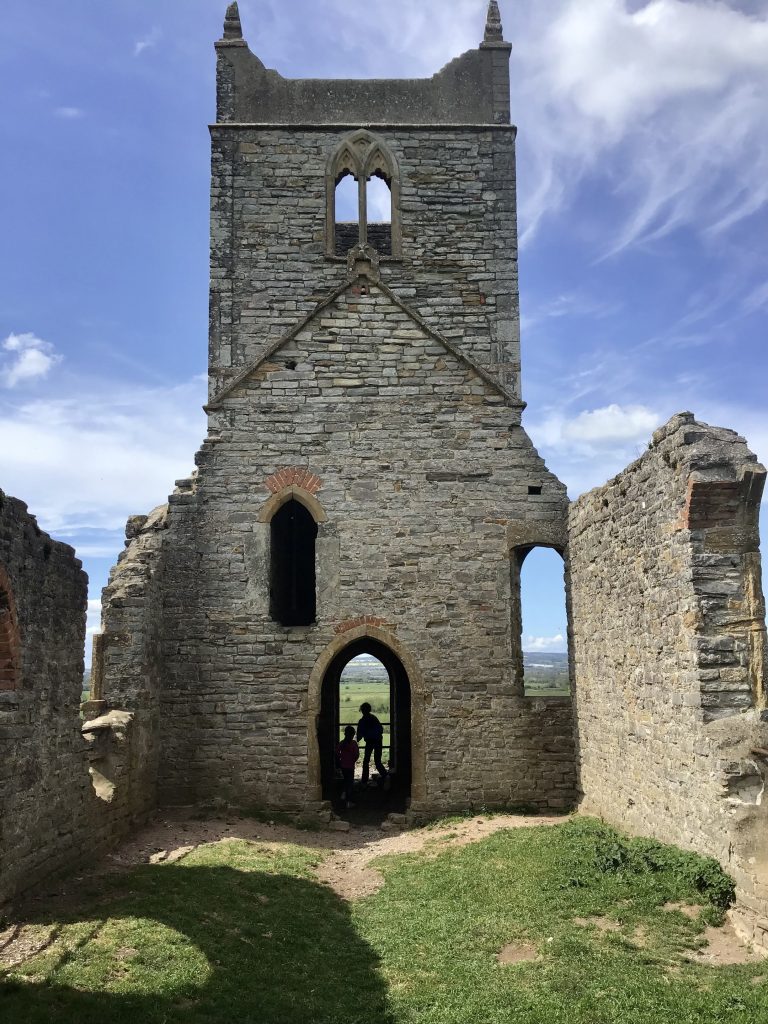
Situated in the village of Burrowbridge, Burrow Mump is an isolated hill that rises above the flat landscape of the Somerset Levels. “Mump” means hill in old English. The Medieval church of St Michael, was built on the top of the hill in the 15th century. Although there is evidence of an earlier 12th-century masonry building. The sides of the hill are ringed with parallel terraces, probably dating back to medieval times when the slopes were used for agricultural purposes.
In 1793, St Michael’s church was rebuilt with a west tower and these ruins can be seen today. In 1946 the land, including the church, was handed to the National Trust in memory of the lives lost in World War I and II. The church is a scheduled monument and classified a Grade 2 listed building.
How to get to Burrow Mump
Burrow Mump is situated halfway between Glastonbury and Taunton, postcode TA7 0RB.
By Car:
On the A361, approx. 25 mins from Taunton. Free parking in small National Trust car park.
By Bus:
Take bus 29 from Taunton to Wells, that stops at Burrowbridge and Glastonbury.
By Train
The closest railway station is Taunton. Then take bus 29 to Burrowbridge.
Level of difficulty
I would rate this in 2 parts: The first part is a steep climb up to the top of Burrow Mump which I would rate as moderate. There is no actual path, and the ground can become muddy and slippery after rain. Therefore, it’s not suitable for people with any mobility issues. That said, it is only a short climb.
The second part is level, and I would rate this as easy. If you opted to walk around the bottom of Burrow Mump and avoided the hill, then it would all be easy.

Burrow Mump and The Somerset Levels Circular Walk Directions
🥾 The walk starts from the National Trust car park. From here, go through the gate and climb to the top of Burrow Mump following a well-trodden path in front of you. There were a lot of sheep grazing on the hill when we visited, which the children liked.
Burrow Mump
Enjoy the panoramic 360° views across the Somerset Levels towards the Severn Estuary in one direction, and Glastonbury Tor in the other direction.  🥾 After admiring the views carefully head back down the way you came. Walk around the hill to the right towards a gate on the other side of the field. Go through the gate and down to the main road. Turn left and walk past a few houses to the churchyard.
River Parrett
🥾 Cross over the road before the bridge and follow Riverside – the River Parrett is on your left.
🥾 Turn right into Burrow Drove and follow the track for half a mile. There are lots of rhynes to drain the land.  🥾 At the end, turn right. It may be muddy along this section. Follow this track until you reach the road (A361), and cross over. There is a path directly opposite. Turn immediately left through a kissing gate and follow a path towards a farm. When you reach the farmhouse, go straight ahead – the path goes straight through the farmyard.
Pathe
🥾 Go through another gate and through a field (keeping to the left-hand side). Take the path uphill to the left which brings you out into the small hamlet of Pathe.

🥾 Turn right and walk along the lane for a short distance. Turn right into a footpath which immediately crosses a footbridge over a small rhyne into a field. 
🥾 Keeping the rhyne on your right-hand side follow a trodden path for about a mile, going through a couple of fields with cows grazing. Make sure you close all gates behind you.
River Bank

🥾 When you reach the River Parrett, turn right. Keeping the river on your left-hand side. You can see Burrow Mump ahead in the distance. Follow the footpath, until you reach The Alfred pub, and the main road.
🥾 Retrace your steps back to the car via Burrow Mump. The summit is the perfect spot for a picnic.

The walk took us about 2 hours at a leisurely pace.
Facilities around Burrow Mump
The walk is very limited in terms of facilities – there are no public toilets nearby or any shops.
But there is a pub in Burrowbridge, the King Alfred, which serves food and drinks. Ideal for some local Somerset Cider!
Best time to hike Burrow Mump
As a result of the Somerset Levels being a wetland area, it can get very muddy during or after rain. We walked on a beautiful sunny day in April and found the conditions to be ideal, mainly because it hadn’t rained for a while. Therefore, I suggest planning your visit in the warmer, summer months or after a period of prolonged dry weather. A clear day will enable you to have the best views from the top of Burrow Mump.
What to wear and bring with you
I recommend wearing a good pair of walking boots/shoes. After rain the paths around Burrow Mump can get muddy, so waterproof footwear is useful. I’ve been using the Salomon X Ultra 360 LTR GTX walking shoes for my recent walks and reviewed them here.
Wear/bring thin layers of clothing which can be easily added/removed depending on weather. On the top of Burrow Mump you are exposed to the elements. There are lovely 360° views from the top, so I suggest taking some binoculars.
Take plenty of water with you to keep hydrated or stop off at the pub on the way round. Otherwise, I recommend taking a picnic to eat at the top of Burrow Mump (if weather permits). Snacks are always a good idea. If, like us, you are walking with children, we find snacks/food are essential.
Always follow the ‘Leave No Trace’ principle and take all your rubbish home with you. Leave only footprints!
Other things to see around Burrow Mump
Glastonbury (10 miles away):
The market town of Glastonbury is worth a visit, not only for its quirky, independent shops, but for the famous Glastonbury Tor and Abbey.
READ MORE: Visit Glastonbury, Somerset
Glastonbury Tor:
Sometimes called the ‘Isle of Avalon’, is known as being one of the most spiritual sites in England. This iconic hill, with the tower of St Michael on top, is associated with tales of myths and legends. For our Glastonbury Tor Circular Walk click here.
Glastonbury Abbey:
Dates back to the 7th Century and is traditionally associated with the earliest days of Christianity in Britain. It is thought to be the burial place of King Arthur.
Wells (The smallest city in England):
The Medieval city of Wells is 18 miles away. There is lots to see including the Gothic Cathedral, Vicar’s Close – the oldest residential street in Europe, the Bishop’s Palace and Gardens, Wells Market Place and the Wells and Mendip Museum.
READ MORE: Guide to Visiting Wells.
Cheddar Gorge (19 miles away)
Take a trip to Cheddar Gorge and caves. You can spend a whole day exploring the caves, museum, walking the cliff top and wandering around the village. Click here for the 4 mile Cheddar Gorge Circular Cliff Top Walk.